From Portus Naonis to the Serenissima Garden
The route begins at the FS railway station in PORDENONE (Km 0.00). With our backs to the Taxi zone of the station entrance we take the right-side pavement of via Pola which follows the railway fence and descends gently eastward along a tree-lined avenue. At the end of the pavement we turn right toward the underpass; we proceed carefully along the pavement of via Cappuccini and cross via dell'Essiccatoio until we arrive at via V. Candiani. Here we turn right. We continue and pass in front of the car-park which is connected to the FS railway station (this may also be considered as an alternative departure point for those arriving in Pordenone by car) and we arrive at the end where we turn left into via Dello Stadio dedicated to the great champion Bottecchia; at the end of the street we go right into via San Vito at the end of which we take the bicycle path of via Largo Cervignano where we continue straight on, passing by the roundabout on our left until the end of the street (Km 2.20) and here we turn left.
After about 80 metres we turn into via Redipuglia and travel along this street for about 100 metres until we reach via Gradisca where we turn right. At the end of this street slightly to the right we take via Martiri delle Foibe, a dirt road, and enter into the Parco dei Laghetti (Lake Park), we cross the narrow passage and follow the dirt path until the end where we take the new bicycle path that leads directly to Porcia along via Pedron by a greenhouse. Here we turn left and proceed first alongvia Pedron which then becomes via delle Acque. At the end of the street we find ourselves on the bicycle path ofvia A. Gabelli, we turn left and continue to the roundabout, which we pass on the right, taking via Cartiera – a stretch of trail with a sharp curve and rather a lot of traffic, at the end of which, turning right, we access the bicycle path of via Correr near Villa Dolfin which is now owned by the Municipality of Porcia.
We continue on the bicycle path and after the crossing with via dell'Agnesina we follow the tree-lined path of Viale Marconi to the bridge with its view over the river park of Rio Bujon. After a few metres we turn right onto via Rivierasca (Km 4.70 ). Detour: if we proceed to the left for about 100 metres we reach the historic centre of Porcia with the Palazzo dei Principi Conti di Porcia (Palace of the Counts of Porcia) on the right and the ancient town with its medieval tower (http://comuni.360gradi-friuli-venezia-giulia.it/pn/polcenigo/). After about 150 metres in the via Rivierasca we turn right along the via del Tulipifero, at the STOP sign we continue left in the obligatory direction to the roundabout and at the second right we take via S. Margherita and after the votive shrine on the right we continue along via Dante Alighieri and keeping to the right we flow into the bicycle path among the houses which ends, after the bicycle underpass of the Sacile – Pordenone railway line, to the traffic light on the State Road 13, the Pontebbana.
We cross the State Road and proceed along the via Roveredo in the district of Sant’Antonio until the next traffic light and here we turn left into the bicycle path (right side) of via Lazio. Having travelled about 500m on the path we turn right into via Umbria, and at the end of the street we turn left into via Maestra Vecchia until the STOP sign in via Ceolini (km 7.80). We pass the crossing and take via Zorutti (a continuation of Via Maestra Vecchia) which is a road with a good dirt bed that we travel straight passing several roads until we reach the STOP sign on asphalt (Km 9.20). We are in the Municipality of Fontanafredda and we cross via Antonini, taking the bicycle path in via Zorutti, we pass in front of a series of factories in the industrial area, which ends in the Fabbro district and after the factory on the left we keep to the right and reach a STOP sign.
We cross over and take via Zorutti and from here the street proceeds with several stretches of dirt surface and others in asphalt; we continue straight on and pass crossings including: via M. Gortani, via di Col di Riva, via F. Baracca,via F. Bellini, via Veronese, via G. Garibaldi, and near a large house on the right the via Zorutti ends (km 14.20). We cross the street, proceeding straight on along the Strada Comunale di Pordenone, we cross the Sacile-Gemona railway line and continue until we reach the big roundabout (up to this point km 15.50).
At this point we have two possibilities to continue our tour: if we turn left toward the industrial area in via delle Industrie and then via Tessere (about 900 metres) we cross via Pordenone – a stretch of provincial road with heavy traffic – if we proceed straight along the Strada Comunale di Pordenone we discover a small dirt ford on the bed of the Ortugna Torrent which we cross carefully to climb up toward Braccomada district to continue then, on the asphalt of via Favola, to the district of San Giovanni di Polcenigo, in via Chiesa and at the STOP sign on the right along via Posta until the crossing with a roundabout (up to this point km 17.30).
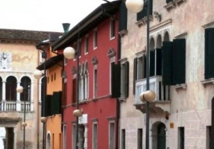
At the roundabout we turn right into via Pordenone and we proceed until we reach Polcenigo (http://comuni.360gradi-friuli-venezia-giulia.it/pn/polcenigo/) and the beautiful piazza Plebiscito framed by its 18th-century palazzi (up to this point km 18.20), we keep to the right along via Gorgazzo amid the evocative old town and after the curve we turn right into via Col Beltit and we reach the fork with via Piantuzze where we turn right and then after about 40 metres immediately left until the STOP sign in the Provincial Road 29. We cross the provincial road, and see in front of us thevia Range which we take, keeping to the track that curves to the left until reaching the area in front of the Angelina restaurant (up to this point km 19.30). (Following the lane here by pushing the bike along the restaurant itself we can visit the source of the Gorgazzo River).
After a break our objective is to reach the characteristic Coltura old town on a road with an average slope of 4%; we cross the small square and start up the via Giuliana, then via Spinet (straight on to the crossing) and at the end to the right in via Mezzomonte, at the shrine we turn left toward via Mena, at the end turn right into via San Michele, at the end left sloping downward into via Rualis until the STOP sign at provincial road 29 (km 21.20). We turn right and continue along provincial road 29 for about 1200 metres, cross the provincial road on the left and take a small downward sloping street that leads us to the Santissima district turning right (visit to a church built in the first half of the 14th century being an important destination for pilgrimages to invoke fertility and then on to the beautiful panorama of the Livenza River which starts up a bit higher) turning left we continue into via Santissima and keeping to the right we reach a bridge over the river which we cross and then take via Longone to the right (km 23.40).
We continue along this street for several kilometres. At the first fork we keep to the left and we reach the STOP sign (km 26.40) and turn left into provincial road 29 and we keep on to the right paying attention to the considerable traffic until we reach a road sign for Fiaschetti where we turn left, following the direction for the Fontanafredda district alongvia Fabio Filzi (km 28.60). At the crossing we turn right into via T. Deciani and we continue for another 100 metres from the fork where we find a small dirt road (direction of the little church of Sant'Antonio) we follow that and arrive at the church situated on a lovely curve of the Livenza River; we continue southward following via S. Antonio until the crossing where we turn left into via Livenza (km 31.80).
We reach via G. Liruti and, turning to the right we continue along via Villorba until the traffic light at the crossing withvia Repubblica State Road 13 (km 34.20). We cross over and continue in via M. Meneghini following the indications for the centre; at the STOP sign right into viale Trieste and via Cavour following the indications to the centre. At the end of the street we curve right along viale P. Zancanaro, we cross the 16th-century Bridge Dei Mori and arrive inPIAZZA del POPOLO surrounded by 16th-century Renaissance palazzi, in the historic centre of Sacile (km 34.92).

